The Ministry of National Security is closely monitoring the movement of Post Tropical Cyclone Idalia as it approaches the Island.
As of the 6 p.m. advisory from the Bermuda Weather Service (BWS), Idalia is a threat to Bermuda.
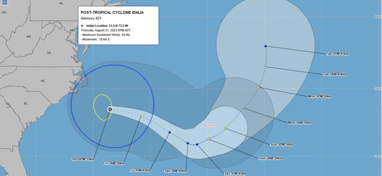
The system’s current position is 444 nautical miles west of Bermuda, moving east at 18 knots. Idalia's maximum winds were 55 knots, with gusts reaching up to 65 knots.
The storm’s closest point of approach to Bermuda is forecast to be within 48 nautical miles to the south south-east of the Island on Sunday, 3 September, at 7 a.m.
Minister of National Security Michael Weeks, continued to share a message of preparedness saying, “While we are all grateful that Hurricane Franklin passed the Island yesterday without causing any major incidents, we continue to monitor Post Tropical Cyclone Idalia’s path.
“It’s imperative that residents take necessary precautions. It is essential for everyone to stay informed about the latest updates from authorities and to secure their properties to minimise potential risks.”
The public should note that tropical storm force winds could begin affecting the marine area on Saturday. The public can expect to experience deteriorating weather conditions related to Idalia.
Residents are urged to take precautionary measures, including trimming loose branches and vegetation, to secure their properties and ensure their safety.
To follow the latest storm updates, visit www.weather.bm.