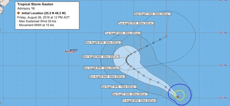
Tropical Storm Gaston, Update from the Bermuda Weather Service:
Currently located 965nm to the ESE of Bermuda and moving NNW at 15kt
- Maintains strong Tropical Storm strength at 55kt
- Still expected to re-develop into a hurricane in the next day or as it encounters more favourable environment (less wind shear)
- Still forecast to recurve North-East late Sunday into early Monday to the East of Bermuda
- Closest point of approach (CPA) is now 449nm to our East at 9am Monday morning
- The CPA distance in this most recent advisory has increased slightly
- Still some uncertainty in the forecast, so expect further slight changes in forthcoming advisories. However, the majority of model guidance still holds Gaston to our East
- Main impacts at this stage continue to fall into ‘Blue Category’ due to building Easterly swells, which will potentially bring hazardous surf/rip currents especially to the South Shore – BWS will likely be issuing a Small Craft Warning nearer the time (tomorrow) for rough E swells, currently expected later on Sunday
Note – as the track of this storm is still not certain, the general public are advised that we are in the middle of Hurricane Season and residents should have their hurricane supplies checked.
BWS will issue advisories on Gaston every six hours, with the latest graphic linked here:
http://www.weather.bm/maps/TropicalStormInfo.asp?WTNTnum=WTNT22